Donna Fagersten had taken refuge at a friend’s home on the top floor as Hurricane Helene tore through northern Florida, leaving a devastating trail of destruction and more than 100 casualties in the southeastern U.S.
As the storm appeared to calm, the 66-year-old teacher, just days away from her retirement, made a fateful choice to return home to rescue her cat.
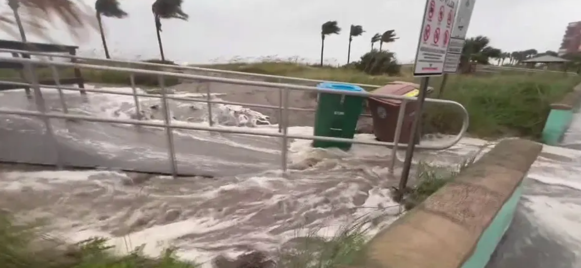
When Hurricane Helene hit Florida on September 26, 2024, around 11 p.m., the Category 4 storm triggered flash floods, forcing residents to scramble for safety. One of the hardest-hit areas was Pinellas County, particularly in the Tampa Bay region, where at least 11 people lost their lives.

Among the victims was Donna Fagersten, a second-grade teacher from Ponce De Leon Elementary in Pinellas County.
According to her best friend Heather Anne Boles, Donna was set to retire the following week after dedicating 35 years to teaching. When the storm hit, Donna sought shelter with Boles and her partner, Mike Moran. As the storm surge rushed in, they retreated to the third floor of Boles’ mother’s home, across from the beach where Donna lived.
Boles recalled that as the storm seemed to settle, Donna insisted on going home to check on her cat, despite Boles’ pleas to stay. Tragically, another surge and high winds returned, battering the coastline.
A neighbor later came to their shelter, reporting that someone had been found floating in the parking garage. They quickly pulled Donna from the water and began CPR, but despite their efforts and the arrival of fire rescue by boat, they were unable to revive her.
Detectives later confirmed that Donna had drowned in her home, which had been flooded with water.
Family and friends have since remembered Donna as a “beautiful person” who was deeply committed to her students and community. In a Facebook post, Mary Gleason Lyons, a colleague and friend, described Donna as a dedicated teacher with a big heart, touching the lives of many students over her 35-year career.
Online tributes poured in, with former students and friends expressing their sadness at her passing and remembering her kindness and warmth.
While Boles and Moran are now left to clean up after the floods, which destroyed most of their belongings, the loss of their best friend is what hurts the most. “This is the worst we have ever seen,” Boles said, reflecting on the storm’s destruction compared to Hurricane Irma, where they managed to keep their home and belongings intact.
On a positive note, Donna’s cat survived, and her friends are working to find him a new home.
Hurricane Helene, which cut a destructive 800-mile path northward, left more than 2 million homes without power and claimed over 100 lives, according to USA Today.
Puppy was left tied to park picnic table in the rain — rescuers save him
Although it is terrible that someone would be so callous as to dump a puppy, fortunately there are good people out there who are prepared to take action and save these abandoned pups.
That happened just now, when a poor dog was abandoned outside in the rain, tethered to a picnic table, until someone came to save him.
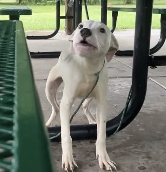
A small dog is shown in a video from Stray Rescue of St. Louis strapped to a table in a nearby park’s picnic area.

The footage shows the dog, who was afraid, alone, and drenched from the rain, yelping repeatedly as though pleading for assistance.
However, as Donna, a rescuer, untied the young dog and arrived on the scene, he immediately warmed up to her, as though he realized he was secure.
According to Stray Rescue of St. Louis, “he was so brave when we first approached, but as soon as we got in the Jeep he curled up on Donna’s lap and let out a deep sigh – that sigh said so much.”
“You’re okay, sweet little baby. We’ll take care of your sweet self in no time at all.
https://googleads.g.doubleclick.net/pagead/ads?gdpr=0&client=ca-pub-3764810839868565&output=html&h=183&slotname=2267562348&adk=1408571436&adf=3052963243&pi=t.ma~as.2267562348&w=730&abgtt=6&fwrn=4&lmt=1724422574&rafmt=11&format=730×183&url=https%3A%2F%2Favokaddo.com%2F2024%2F07%2F23%2Fpuppy-was-left-tied-to-park-picnic-table-in-the-rain-rescuers-save-him%2F%3Ffbclid%3DIwY2xjawE1ePxleHRuA2FlbQIxMAABHY1a76ge8AInOF7DgT0DE60rEro6r8oZDCeJ_W7n601OiTeR0CDtWFIkyw_aem_3AR5wba2T_W2FNYyufZ-Wg&wgl=1&uach=WyJXaW5kb3dzIiwiMC4zLjAiLCJ4ODYiLCIiLCIxMDkuMC41NDE0LjE2OCIsbnVsbCwwLG51bGwsIjY0IixbWyJOb3RfQSBCcmFuZCIsIjk5LjAuMC4wIl0sWyJHb29nbGUgQ2hyb21lIiwiMTA5LjAuNTQxNC4xNjgiXSxbIkNocm9taXVtIiwiMTA5LjAuNTQxNC4xNjgiXV0sMF0.&dt=1724422572822&bpp=1&bdt=286&idt=254&shv=r20240821&mjsv=m202408150101&ptt=9&saldr=aa&abxe=1&cookie=ID%3Dd6f422181fa8e320%3AT%3D1712754368%3ART%3D1724422574%3AS%3DALNI_MbQ8K8Uz_tQiOWk9_ho73iGWbUvXg&gpic=UID%3D00000de663175333%3AT%3D1712754368%3ART%3D1724422574%3AS%3DALNI_MZzkvLBsYSBf99BTmrLqXAWredf6A&eo_id_str=ID%3D880422cb866d8cdc%3AT%3D1712754368%3ART%3D1724422574%3AS%3DAA-AfjYIkHBaiiV25sK_LhuhTK3y&prev_fmts=0x0%2C1100x280%2C730x183%2C730x183%2C730x183%2C1362x728%2C1005x124&nras=3&correlator=2170257321562&frm=20&pv=1&rplot=4&u_tz=420&u_his=1&u_h=768&u_w=1360&u_ah=728&u_aw=1360&u_cd=24&u_sd=0.8&dmc=8&adx=131&ady=2895&biw=1362&bih=728&scr_x=0&scr_y=0&eid=44759876%2C44759927%2C44759837%2C31086226%2C95334829%2C95338226&oid=2&psts=AOrYGsnZAyL6t0orVINEoufoTf09JCAA-zUqatiYxF8mm1V2qB_BZpiFe0_1VVaZF_0WGNWLG-mmBIFBuPrn_rzAE3O9Ag8f%2CAOrYGsk7TmfRPC59cNMDjIbAK-Lpyr1PnsEZodz3plZcIKg5D8ybit81C0IvUMhxhdL-Cz951wl20MPE7kLZP4K07_ah7MEs&pvsid=2413715522371453&tmod=1712846900&uas=0&nvt=1&ref=https%3A%2F%2Fl.facebook.com%2F&fc=1920&brdim=130%2C0%2C130%2C0%2C1360%2C0%2C1123%2C703%2C1383%2C728&vis=1&rsz=%7C%7CopeEbr%7C&abl=CS&pfx=0&fu=128&bc=31&bz=0.81&psd=W251bGwsbnVsbCxudWxsLDNd&ifi=6&uci=a!6&btvi=5&fsb=1&dtd=2097

The dog was named Wilbur by the rescue. He was “covered in ringworm,” as they found, and they gave him medicinal baths as treatment.
Wilbur was in a caring foster home a few days after his rescue. The Dodo was informed by his foster mother that he was a “snuggle bug” and “doing great.” She remarked, “He wants nothing more than to be loved.”
Although Wilbur’s origins are unknown, it is obvious that he hasn’t been getting the love and attention he deserves. However, the little dog appears to have a bright future ahead of him.
Facebook said, “He’ll never have to be lonely or muster up that much bravery ever again.” This is from Stray Rescue of St. Louis.
I’m grateful that you saved this tangled puppy, pulled him out of the wet, and gave him a fresh start. The expression on his face indicates that he knows he’s in capable hands.
Kindly tell this story to everybody who enjoys dogs!


Leave a Reply